Showing posts with label volcano. Show all posts

Thursday, September 13, 2018

Olivia


"Olivia"... the hurricane, er, tropical storm, er... event that never really was this past week... at least not here in sheltered Kona. Regardless, we have had a full summer of hurricane scares, warnings, preparations, close calls, earthquakes, eruptions, wildfires, and overall angst out here it seems. It's been an interesting summer on the Big Island.

So, Olivia, and to all your friends and named events... Thanks for stopping by.

Enjoy!
Thursday, June 7, 2018

Vocanic Time Lapse


This set of time lapse videos is extremely well done. It pains me that this event is so close to where I live and yet because of the location I'm unable to capture any of it. I would certainly be doing time lapse imagery if I could get in there however.

Enjoy!

Thursday, May 31, 2018

sUAS Rescue

The other day, the local USGS folks, with help from the Department of Interior Unmanned Aircraft Systems (UAS) Kīlauea response team, was monitoring the eruption activity in the Leilani Estates Subdivision area when they got wind of someone "trapped" in the inundation zone. Let's set aside for a bit asking why someone would remain in their home when a lava flow is bearing down on them and concentrate instead on how some pure scientists and tech geekheads helped save a life. This is pretty remarkable stuff.

First, watch the video here: USGS UAS mission helps with a successful rescue on May 27

Then have a look at where it all went down in context:


All I can say is, Wow. Just. Wow.

Saturday, May 19, 2018

Big Island Eruption May 2018


This Google My Maps page is a crowd-sourced, community effort that is being updated quite frequently. It's a great resource for those wondering what is going on out here, where the action currently is, and how much land and property have been affected. I freely admit that I'm quite late adding a page about all this here, but it's likely I'll add more in the days ahead. Honestly I've been too taken in by the events and slack-jawed over it all to do much.

Sunday, December 10, 2017

Hawaiian Pu'u


My Mavic has been out of service (OTS) since I got back from the mainland in mid-October. DJI eventually fixed it for free since the problems were within my warranty. I also had a DJI Care Refresh policy so it would have been free anyway. So it was great that a Friday afternoon coincided with a perfectly clear, wind free day to let me get up in my little bird again. Over time I hope to fly many more pu'u around the island. For now here's a short look at countryside I get to see on a regular basis.

Enjoy!

Monday, July 23, 2012

Vog

(A current animated version can be viewed -Here-)

What is Vog?  The University of Hawaii's School of Ocean and Earth Science and Technology (UH SOEST) defines it as follows:

Vog is primarily a mixture of sulfur dioxide (SO2) gas and sulfate (SO4) aerosol. SO2 (invisible) reacts with oxygen and moisture in the air to produce SO4 aerosol (visible). SO2 is expected to be the main problem in areas near the vent (Hawai`i Volcanoes National Park, Pahala, Na`alehu, Hawaiian Ocean View Estates) and SO4 aerosol is expected to be the main problem at locations far from the vent (Kona and farther north and west).

In LA or NYC they'd call it Smog.  The sources may be slightly different, but the effects on people and plant life are largely the same.  In Hawaii it's a natural process and results from eruptive activity at the Kilauea Volcano.  As the graphic above shows, the areas most affected by the vog here are those immediately west of the eruptions themselves that lie on the path of normal trade wind patterns.

Over the years I've posted a number of photos showing what the sky looks like at sunset when vog is particularly evident... but until you see where it comes from and where it goes it's kind of hard to grasp what the effect is here.  The SOEST graphic above is updated frequently and is part of an ongoing Vog Measurement and Prediction Project.  It shows output in graphical form from the HYSPLIT dispersion model.  Those who live here really don't need a reminder.  We've seen it just about every day since Halemaumau blew up in April 2008.

"vog" sunset taken above Puako Mar 7, 2008


Tuesday, March 6, 2012

End of an Era


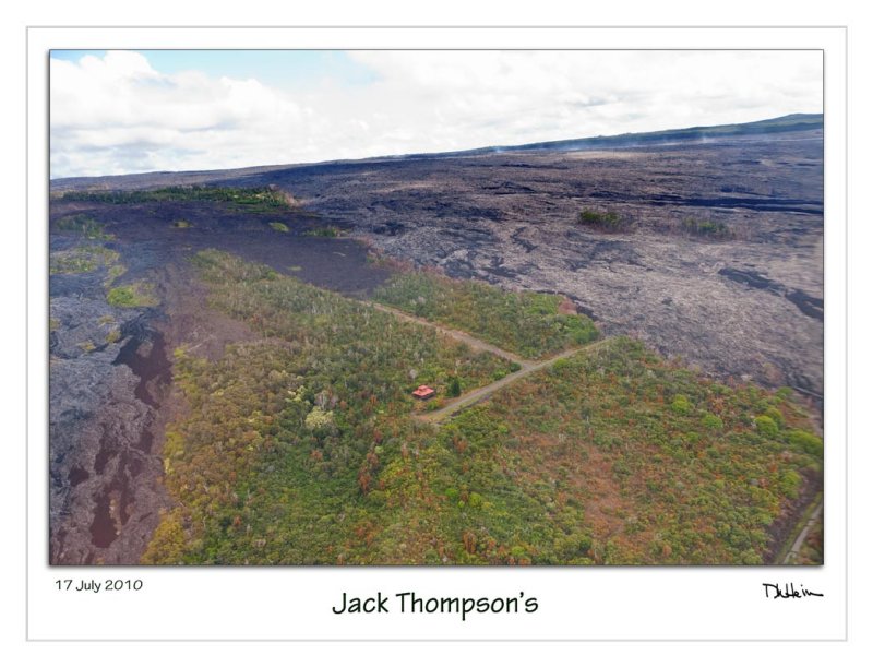
The last home in the Royal Gardens Subdivision is no more. Jack Thompson's house, which had survived countless assaults by Madam Pele since the current phase of eruptions started in 1983, was the 75th, and final house in the development to be claimed by lava from the Puu O'o vent this past Friday, March 2, 2012.  Royal Gardens was originally developed with 1,500 lots.  Fortunately only 75 houses had been built when the eruption started reclaiming land back in 1983.

Much more information, including this video and many other photos, can be found on Leigh Hilbert's excellent Hawaiian Lava Daily blog site.

This was my photo of the property taken a couple of years ago during a Blue Hawaii Helicopter's flight down over the volcano.